08/02/2022
We had a long day ahead of us.
According to the plan, we drove north to the Canadian border today.
Michigan is the only state that spans two peninsulas. Initially, the name Michigan just meant the lower peninsula. The Upper Peninsula is separated from the Lower Peninsula by the Strait of Mackinac, which connects Lake Huron to Lake Michigan. The tourism role of the Upper Peninsula is outstanding.
The Mackinac Bridge spans the Mackinac Strait and is the third-longest suspension bridge in the world. That's why the inhabitants of the Lower Peninsula are jokingly called trolls because they live under (i.e., south of) the bridge.
Previously, the Upper Peninsula was not part of the mainland. The only way to get here was by air or water until the Mackinac Bridge was built in 1957, thanks to an engineering feat! It is one of the longest suspension bridges in the world; its length is 8038 meters. Its towers are 150 meters high. Thousands come to celebrate the bridge's construction every year, and then people walk across the bridge (Labor Day Walk)!
The inhabitants of the upper peninsula call themselves Yoopers and speak a special dialect. Only 3% of the population lives here.
They didn't want to make the Upper Peninsula part of Michigan for a long time. Around 1830, when the population reached 60,000, it was possible to apply for a declaration of the state. She wanted the 51st state to be named Superior (after the lake). But it didn't come to that in the end.
At that time, the so-called Toledo War (1835-36) took place, an almost bloodless border dispute over the area between Michigan and Ohio, today's Toledo. Control of the Maumee River estuary and associated inland waterway opportunities, as well as good farmland to the west, were viewed as valuable economic assets by both sides. In the summer of 1836, the United States Congress proposed a compromise, giving Ohio the Toledo Strip, which means an area of 1,200 km², and Michigan, giving the upper peninsula of 23,000 km². The northern region's mineral resources later became Michigan's economic capital. Still, at the time, the compromise was considered a bad deal. But 5 years after Michigan became a state (1837), a copper deposit was found here. By the mid-20th century, miners produced more than 5 million tons of copper. But that's over; the last copper mine was closed forever in 1995. The Upper Peninsula is also quiet again, and nature is the master!
Let's see what we discovered:
After breakfast, we left for Mackinaw City. This is about 2 hours from Traverse City.
First, we turned to the nearby McGulpin Point Lighthouse.
It was acquired in 1868, commissioned in 1869, and operated for 37 years. It is one of the surviving lighthouses in the strait.
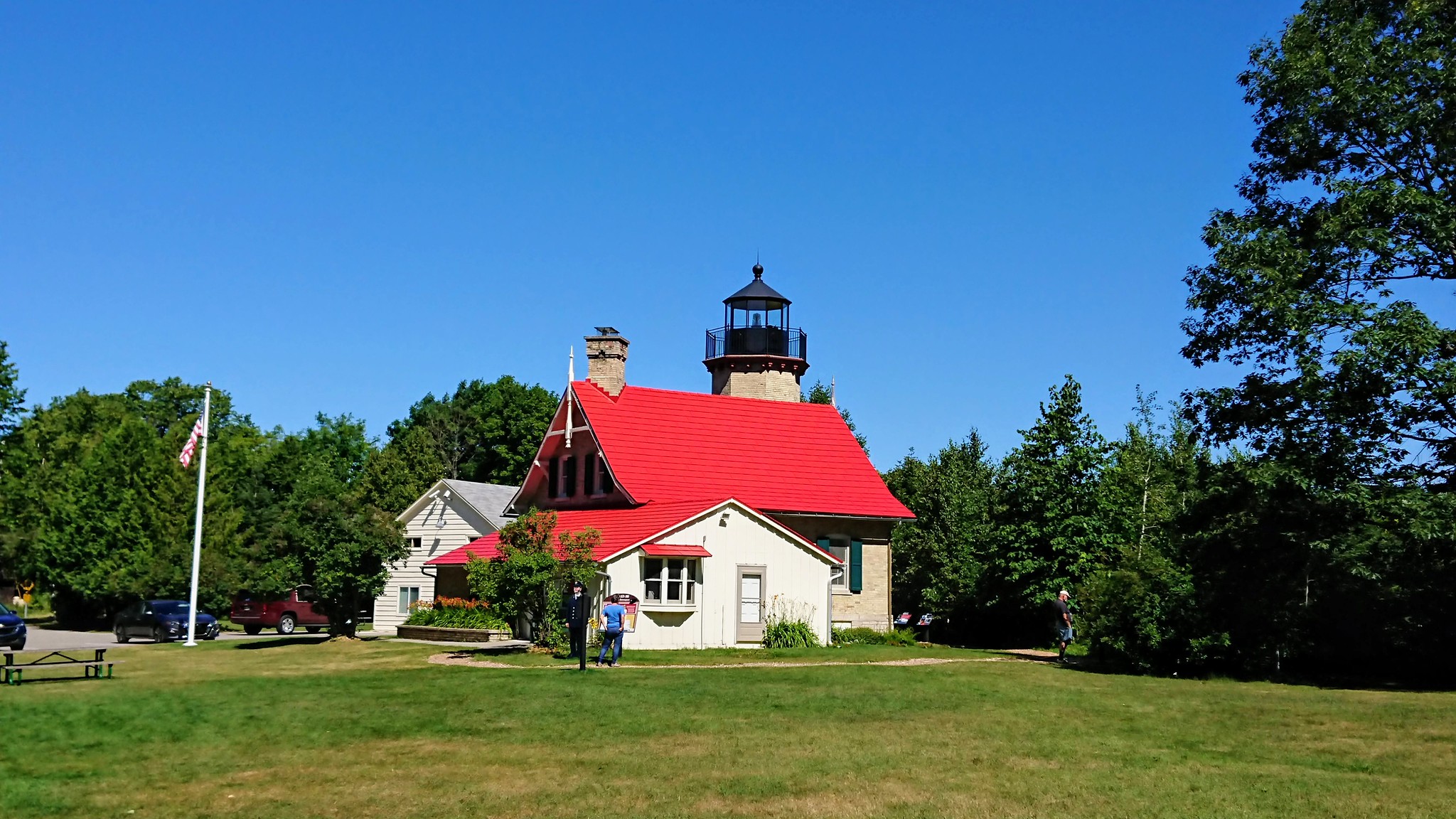
James Davenport was the only lighthouse keeper here and served for 27 years. In 1906 another was built in Mackinaw City, creating two lighthouses. The new one was in a better location because you could see both Lake Huron and Lake Michigan. They removed the lights, put them away, and sold the property because it had value. It sat vacant for 32 years, then in 1938, two Chicago teachers bought it and turned it into a summer home.

She is about 40 years long. It was subsequently sold to the Peppler family, who died there until their deaths. In 2008, Emmet County bought it and turned it into a museum and received new LED lighting.

You can also climb the tower, where 44 steps lead to the top.
Visiting the museum and the tower costs $3 per person.
Another interesting point is that there are an estimated 6,000 shipwrecks on the bottom of the Great Lakes, 1,500 of which are in Michigan state waters. The deepest known wreck is the 1867-built steamer Congress, which sank on October 4, 1904, due to a fire on board. Today it is 50 meters deep. The autumn months are the most dangerous for boats on the Great Lakes when the weather is at its roughest.
There are information boards outside, including some interesting stories about the shipwrecks. Additionally, a tiny house is at the back, which is part of the museum.
These exterior parts can be visited free of charge anyway.
Inside is a souvenir shop where you can buy a ticket if you want to go up the tower or visit the museum. A man was a salesman in the shop and a tour guide because he briefly told us the story and then we went up the tower. The view from the top is gorgeous too!
The is a small sloping road next to the lighthouse leading to the water. One can also walk down, but we went down by car; there is a small parking lot.
A fantastic sight unfolds before your eyes. There is a rock/rock of historical importance called The Big Rock at McGulpin Point.
This piece of rock was already used by local Indians and French explorers to measure water levels while they sailed in canoes on the murky waters between the Lower and Upper Peninsulas. A kind of navigation aid since 1615.
And in the background is a beautiful view of the Mackinac Bridge.
We couldn't wait to walk up to this bridge, but another attraction awaited us at the foot of the bridge.

Mackinaw City is actually a small town on the upper tip of the Lower Peninsula. The Mackinac Bridge runs from here to St. Ignace on the Upper Peninsula.
Ferries to nearby Mackinac Island also depart from here.
It is a top-rated tourist destination. The main attractions are Fort Michilimackinac, the bridge, and the Old Mackinac Point Lighthouse.
Since we had more attractions and programs planned for that day than usual (haha), we had to decide what to miss.
There are so many natural attractions in the Upper Peninsula, but they are so remote. So, unfortunately, they are now canceled.
There is a significant landmark near the Canadian border, and it is also another hour from here.
We also decided at the time that we really wanted to go to Mackinac Island!
Under the bridge is Michilimackinac State Park, Michigan's second such park. It was founded in 1909. Here you will find Colonial Michilimackinac, one of the most crucial fur trading posts of the 18th century, and the Old Mackinac Point Lighthouse. The view alone is worth stopping for a while.
The treasures of the past come alive in the 18th-century fortress and fur trading village. It was reconstructed based on historical maps and 60 years of archaeological excavations. You suddenly find yourself in 1779 during the American Revolution. British soldiers in period clothing and French-Canadian merchant families tell stories from the past.
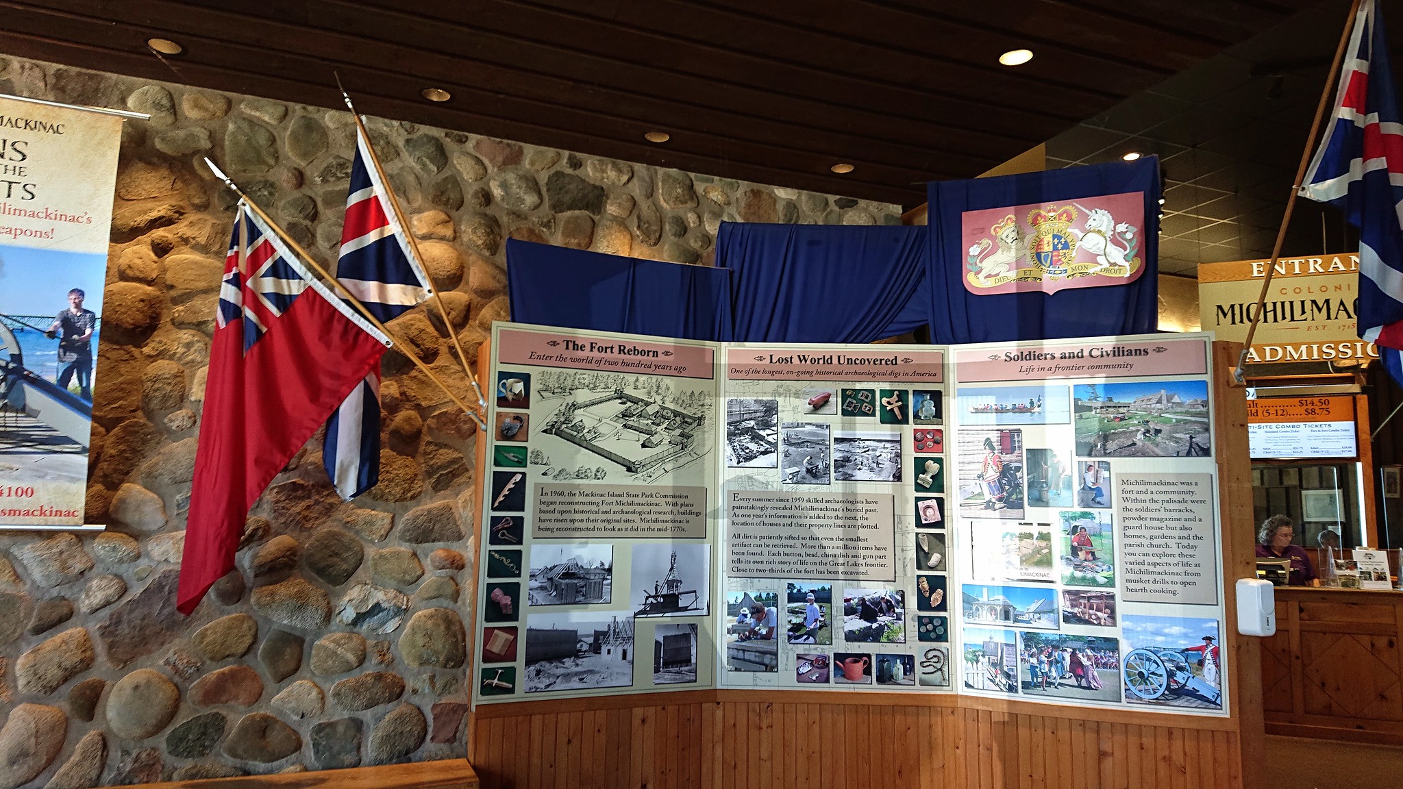
We didn't go inside due to time constraints. We only looked at the lighthouse from the outside, located outside the fortress in a park.
The view from here is also terrific. The bridge, the water, and the lighthouse itself are stunning.

The Old Mackinac Point Lighthouse was built in 1889. Since then, he has been helping passing ships navigate the straits. It is also called the "Castle of the Strait". It was closed in 1957, and the renovated lighthouse only reopened in 2004. A shipwreck museum can also be visited in its garden.
The price of the entrance ticket here is $9.75.
It was almost time to go!
We knew the bridge has a toll, but we didn't know where or how to pay, so we asked at the visitor center at the foot of the bridge. They said there would be a toll booth, and you can pay there.
Then it turned out that these gates were just on the other side of the bridge.
So we set up Waze to figure out where to turn onto the bridge, which we missed initially, but then we were already in the right direction.
The bridge is really unique and wonderful. We weren't afraid of it. (A lot of people find it scary for some reason.) Fortunately, we didn't find the Chesapeake Bridge-Tunnel scary either.
But maybe I wouldn't have said that if the wind was blowing or the weather conditions were like this.
But we were lucky, shall we say!
There were indeed tollbooths on the other side of the bridge; we stopped at one of them (there was no queue). The woman greeted us very friendly and asked how our day was so far. We had to pay $4, and we were in the Upper Peninsula!
From there, we headed north to the Canadian border, which is about an hour away.
Additional Photos